The concept of a mental map refers to an individual's personal point of-view of their own world. These views can be put on paper in the form of maps drawn or descriptions written from memory alone. Mental maps can simply indicate locations, but they can also emphasize the importance or significance of certain places.
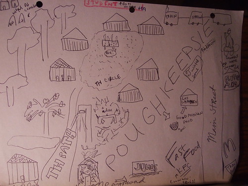
I collected maps from friends and family and left paper asking visitors to Open Office to draw maps as well. I ended up with 9 maps. Unfortunately I didn't get maps from as wide a variety of people as I'd hoped, I still got some interesting results. Most of the students chose to draw only campus and drew accurate maps for the most part. Not surprising given the amount of time we spend on a relatively small campus. One student wanted her map to be accurate and got so frustrated when she couldn't make it look the way she wanted it to that she gave up. When students did include parts of Poughkeepsie they usually included the train station and nearby restaurants and not much else. As a student, I'm not surprised and I think it says a lot about the way we view our area. Also not surprising, the only local student who drew a map included much more of the surrounding area - Rt. 9, residential areas, the Hudson, the bridge, and the downtown Poughkeepsie area. DeeDee's map of the Bio Building (with mentions of parking and the Retreat) provided a great visual of how a visiting professor who is on campus once a week sees things.
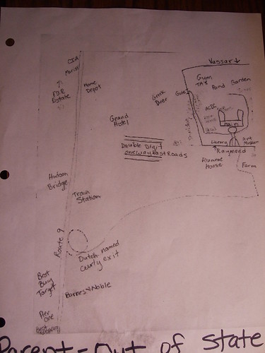
Finally, both of my parents drew maps. Their perceptions of campus and the surrounding area were the ones I found the most interesting because I hadn't anticipated what their views would be. My mom's was mostly of Poughkeepsie and included a lot of landmarks (CIA, Marist) and stores (especially ones we've shopped at to furnish my various rooms on campus). I also got a kick out of her labels when she couldn't remember proper names - 44/55 became "double digit one way fast roads" and Spackenkill became "Dutch-named curly exit." My dad, a lover of maps, drew a really accurate map that was also heavily influenced by the places he's been as a parent - hotels, restaurants, storage places, etc.
While I was impressed by how accurate some of the maps were, I was more drawn to the maybe less accurate maps that seemed to contain memories/opinions/emotions in some way. I felt like I got from these maps more than just an idea of a person's visual image of Vassar and Poughkeepsie, but I got some insight into their visceral relationships. For example, on DeeDee's map, she labeled the window and added "with gorgeous view that we never see 'cause we need it to be dark to see the screen." A couple people indicated where on campus their rooms/houses were. I think these maps are closer to the goal of mental maps - an attempt at understanding how people see and understand their own world.
Here are some of the maps. Click for more.
No comments:
Post a Comment